
The Light Pollution Map makes it simple to find dark sky areas where there won’t be any light pollution, allowing for the best stargazing, observing, and photographing of the night sky! But it’s more than simply a map of light pollution.
There is a ton more, including a live map of the aurora borealis, notifications for meteor showers, super moons, lunar eclipses, moon phases, data on the aurora and magnetic fields, a tracker for the international space station, and much more. You can navigate the night sky with Light Pollution Map.
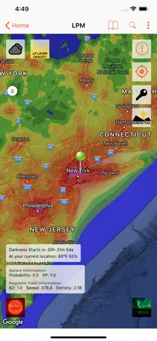
A LIST OF EVERY FEATURE:
- Find dark sky viewing places close to you using this highly accurate, customizable, and dynamic light pollution map.
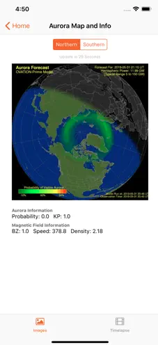
- For those who are serious about chasing the aurora, you may view live data about the aurora borealis, including KP values, magnetic field information, and much more.
- Live auroral visibility maps for the northern and southern hemispheres, along with extra time-lapse options.
- Informational widgets for Aurora (today widget).
- ISS Tracker, which provides real-time information about international space stations such as their location, appearance, velocity, altitude, and much more.
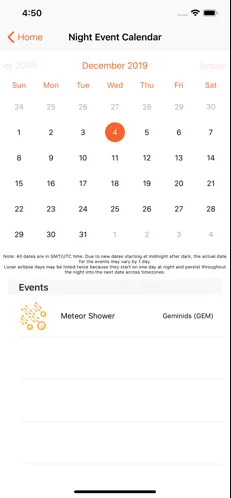
- You can locate calendars for astronomical events, supermoons, and meteor showers using the night sky event calendar.
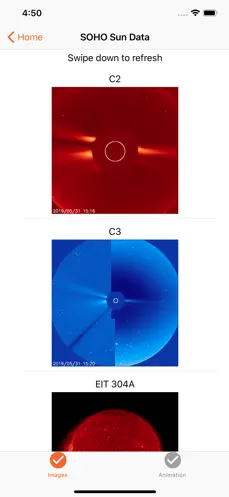
- Real-time solar image streaming from NASA’s Solar and Heliospheric Observatory.
- A timer that counts down from total darkness to the point in the night when the sky is the darkest.
- Tell you when it begins to get light outdoors as well.
- Today’s Astronomy Photo of the Day from NASA! A brand-new one to view each day!
- A local temperature meter that lets you know before you go outdoors whether you need to pack a sweater.
- Local cloud coverage indication to help you decide whether you can go outside before it gets too dark.
- A cloud cover overlay that can be used to locate areas with clear skies at night on the main map.
- App settings for personalization.
- Details on the moon, including its phase, its rise and set times, when the full and new moons will be visible next, etc.
- A tool that shows you the moon’s orientation, which you may use to determine where it will be at any given hour or on any given day.
- To prevent light pollution from adjacent cities on the map, enable a horizon-safe radius circle.
- Local push notifications and alerts for the Northern/Southern Lights (Aurora Borealis).
- Alerts and push updates about Aurora Borealis activity worldwide.
- Push notifications and warnings for meteor showers.
- Push notifications and alerts for the supermoon.
- Push notifications and alerts for lunar eclipses.
- Your preferred dark sky locations can be saved and loaded.
- Use the Apple Maps app to find your saved places.
*** The pro version of some of the aforementioned capabilities can be obtained through an optional in-app payment. Every purchase is greatly appreciated and helps us keep the software up and running.
Note: Data are loaded online via Light Pollution Map. WiFi or an internet connection is necessary, and we are not liable for any data consumption fees assessed by your service provider.